The perfect tool for showing how a geographic location changes through time and a useful tool to interpret other resources, including directories and photographs.
“All good adventures begin with a map”, Treasure Island
Guide to resources inside and outside your collection
There are a wide variety of maps, although most people think of Ordnance Survey, and that is usually what they want.
Printed – engravings of town plans, Ordnance Survey and other published maps which are sold and for which there are numerous copies. Some may be annotated by their owner before being passed on e.g by the planning department
Manuscript – one off maps surveyed and drawn by mapmakers (although a few copies may have been made). These would normally be in an archive, although copies may have been made digitally or on microfilm, or in a printed volume, so there may be access to copies in a library.
Early mapping:
- Mapping as we understand it goes back to 16th century although very few maps from the period.
- County maps – maps were made of the county, often more for decoration so can have limited detail, and there may be errors.
- Town Plans – large towns and cities began to have town plans produced from 17th century onwards, the first often being Speed maps c1605.
- Maps can also come in all sorts of other formats. Local maps are useful for enquiries and finding where places are just as much as for information for customers.
Ordnance survey:
- Ordnance Survey began mapping the UK by targeting key military locations in Southern England in the Napoleonic wars. Over the early nineteenth century they slowly created county based surveys across the UK at 1” to the mile.
- In the 1880s they published maps of the whole country at 6” (1:10,000) and 25” (1:2500), which were revised for a 2nd edition c1900 and 3rd edition c1914. Later editions were created, and in 1950s they resurveyed using a new grid system.
- Most Libraries will also have the 1:25,000 and 1:50,000 and similar folded maps both current and historical.
- More information about the history of the Ordnance survey can be found here: https://www.ordnancesurvey.co.uk/about/history
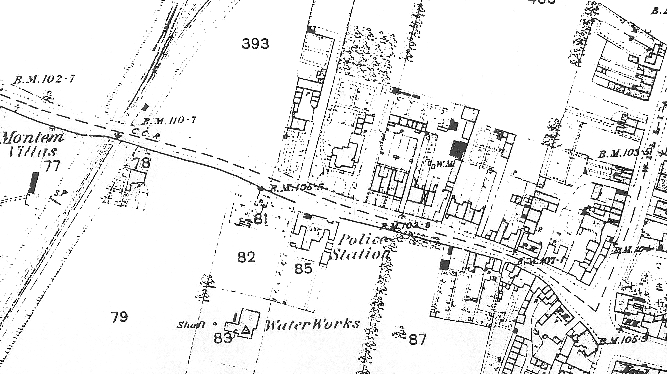
1888 25″ Ordnance Survey map of Worcester – note how much detail it includes
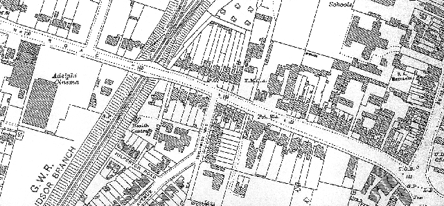
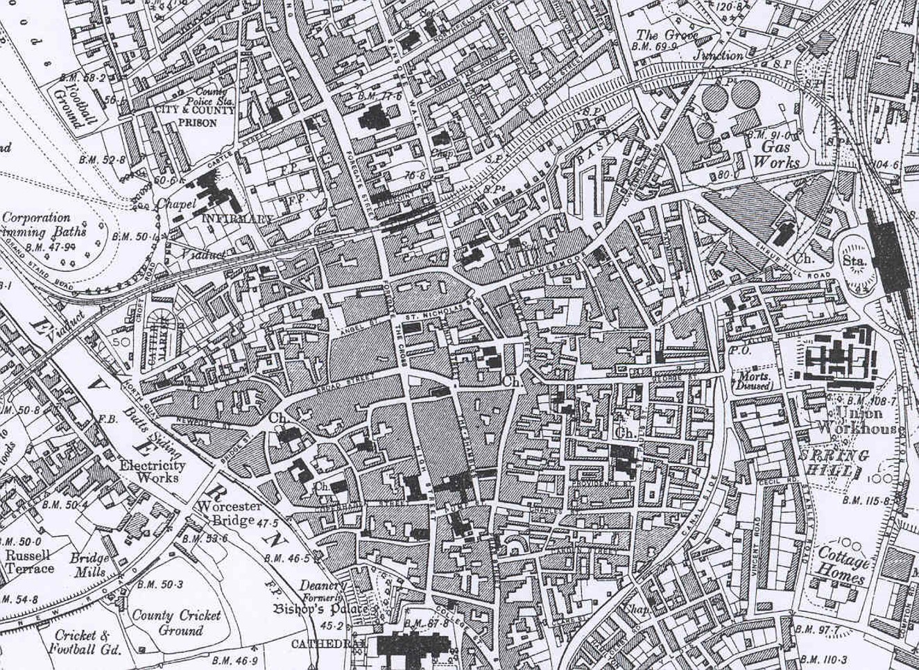 1901 6″ Ordnance Survey map of Worcester – to include all the buildings in the city centre some are merged together
Manuscript:
Manuscript maps are usually found in archives although some have been digitised or printed and are also available in libraries. Coverage will vary a lot as maps were expensive to create, some have not survived, whilst other may be other record offices or still in private hands. The main types are:
- Estate – created by an estate owner so they can manager their land and also to show off their wealth so they are usually nicely decorated. May have tenant details. Very expensive so only shows land belonging to owner and infrequently created.
- Enclosure (late 18th-mid 19th century) – map created to show new landscape after land was Enclosed.
- Tithe – early 1840s, produced to go alongside apportionment when system of Tithes was changed. Apportionments have landowners, tenants, land name, use and size included, related to numbered pieces of land on the map.
- Inland Revenue Valuation Office Survey of 1910 (sometimes called New Domesday), which was a national land survey, so gives similar information to the earlier tithe survey.
- Local Authority development maps: Local authorities produce mapping, many of which were commissioned for reports and consultations. These can be goldmines of local information.
Others:
- Street Atlas – most towns have street atlases such as A-Z or published by the local council
- Goad – maps of town and city centres showing the occupants of shops. Originally for fire insurance purposes mostly used today by geography students! Part of the Experian group now so now officially called Experian-Goad maps.
- Geology – maps of underlying geology published by British Geological Survey (www.bgs.ac.uk).
- Other maps may cover electoral divisions, land use, streets, services, sewers etc.
Online mapping:
National Library of Scotland has digitised large numbers of UK maps: http://maps.nls.uk/index.html including
- Six-inch England and Wales: http://maps.nls.uk/os/6inch-england-and-wales/
- 1:10,000 1940s-1980s: http://maps.nls.uk/os/national-grid/index.html
Prints of current mapping can often be accessed via local authority webpages, for example https://mol.rbwm.gov.uk/mol/map/. Check with you own local authority to see what is available to you and your users.
Gazetteer of British Place Names is a free resource that allows you to search for a British place name and the gazetteer will tell you the historic and current county, OS grid reference and longitude and latitude. Very useful for researching places and cross-referencing with old maps and other sources.
Other good older map websites include:
- http://www.visionofbritain.org.uk/maps/ for the national maps portal or go through your own local area page, for example: https://www.visionofbritain.org.uk/place/53
- https://www.oldmapsonline.org/
- Catalogue of British Town Maps is a free online catalogue of extant British town maps held in UK public archives and libraries. Essential tool for finding historic maps of a town or city.
- Layers of London, with occasional coverage outside of the M25, this is an innovative project to provide digitised historic maps of London and allow organisations and individuals to data to the map (for examples photographs of buildings and streets). Some London local studies libraries have contributed HLF funded project.
Historic Environment Records (archaeological databases for counties and unitary authorities, previously called Sites and Monuments records) are GIS based and have access to historic digital OS maps and sometimes other historic maps, as well as aerial photos and LiDAR data so it is worth checking with your local HER so you can advise what they have.
Modern maps are widely available online, though Bing https://www.bing.com/maps also gives you access to smaller scale OS mapping.
Obtaining new mapping
Local authority licenses often allow them to print maps for use by the local authority. Your planning office may be able to supply you with a set inexpensively. Though online versions of mapping can be updated easily, obtaining printed sets captures your area in time and users can then compare maps over time to see how areas have developed. Due to changes in how maps were published, many archives and local studies libraries will have stopped acquiring 1:1250 and 1:2500 OS maps in the 1990s.
Microfilm copies of the first and second editions of the County Series 1:2,500 is available from the British Library.
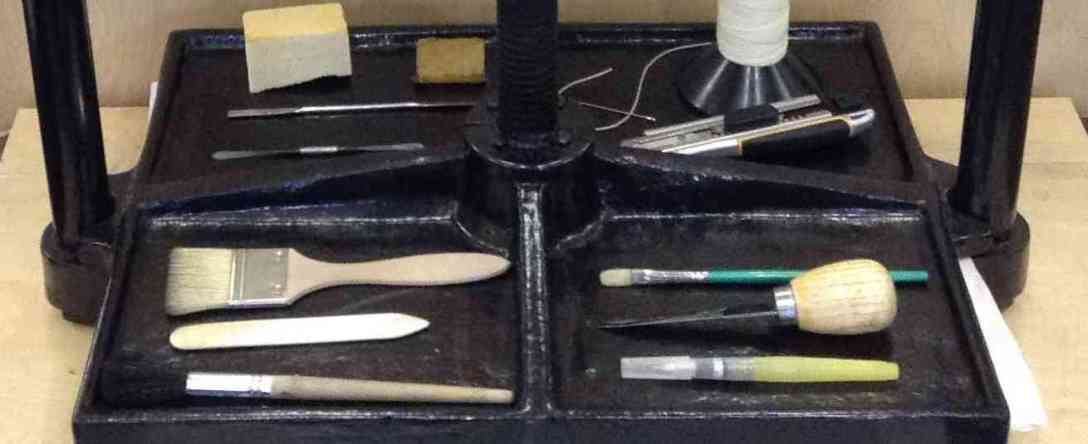
Preservation & storage
Maps can be stored vertically in hanging cabinets, with strips attached with holes in from which they are hung, or else in flat map cabinets. Each has pros and cons. Vertical cabinets can be easier to go through.
Maps should not be folded as they will create weaknesses, although this can be hard due to space.
Some local studies libraries have maps on open access in cabinets, whilst others need staff to get them out. If open access please be aware of risk of public using big heavy map cabinets, and how to reduce maps being replaced in the wrong order.
Well used maps should be covered in conservation grade plastics. Conservation suppliers sell this plastic in rolls which can be folded and cut to size and then sealed with double-sided tape or sealed using special equipment. You can also purchase also sell large wallets made in common sizes.
Physical arrangement and cataloguing
OS maps have two different grid systems depending on whether they were produced before or after World War II.
Pre-World War II maps are numbered using a county-based two-level grid system whilst the post-war maps use the same latitude and longitude grid system OS uses today.
OS maps are not always easy for the pubic to use, and often need maps with the grids and map references marked on. They can be a struggle for staff too! Indexes can be produced which can make it easier for customers to find the right map.
Copyright
Maps are considered as artistic works, some of which have been published and some of which have not. Many maps are also based on OS mapping which makes life more complicated. See our copyright pages for further information.
Maps usually cannot be copied for planning applications, and people will need to buy and official copy. Although since most libraries don’t have 1:1250 and 1:2500 maps from the past 30 years there will be fewer people asking for them for that purpose.
Innovative projects
History Pin uses maps to connect places to stories and images: https://www.historypin.org/community
Similar regional projects have been created, including Know your place West of England http://www.kypwest.org.uk/.
Know your place West of England includes the KYPWilts Postcards Project:
Bombs over Bucks uses the County’s mapping to show where bombs fell during World War II: https://buckscouncil.maps.arcgis.com/apps/webappviewer/index.html?id=6ab95f847d364d7597517809f7ffd2ac
For a historic orchards projects copies of maps were created which people coloured in the areas of orchards in an area, which conveyed the local importance as people could see how much land was used for this purpose at a glance. On similar principles you can use copies of maps for all sorts of base layers, annotating or colouring in items.
Further reading
JISCMail map curators group: https://www.jiscmail.ac.uk/cgi-bin/webadmin?A0=lis-maps

I’d like to add a really useful online resource for Tithe maps in Wales.
https://places.library.wales/
You can search and view the transcribed apportionments through the website. I’ve found this very useful when dealing with emailed requests, as I can send a screen shot or link and pin point the exact place with the map overlay. I do like to check the physical resources too though.
Essential reading for anyone working with historic Ordnance Survey mapping: Ordnance Survey maps: a concise guide for historians: Third Edition, revised, corrected and expanded, Richard Oliver
The Charles Close Society 2013, pp 320, illus., hardback, ISBN 9781870598316