Most of us will have examples where items in our collections aren’t what they seem – a photo is not of the place where it says it does on the back; a book has a map which may be a little dubious and fanciful; or a book may have information which isn’t backed up by footnotes or other indications where it came from
I’ve been caught out a few times at events. In Derby I was showing a group round on a tour and had photos of their village out to show them examples of what we held in the library, but they immediately said some of Well Dressing photos I had out couldn’t be their village as the theme was religious and their village never did those, even if the back of the photo said it was that village.
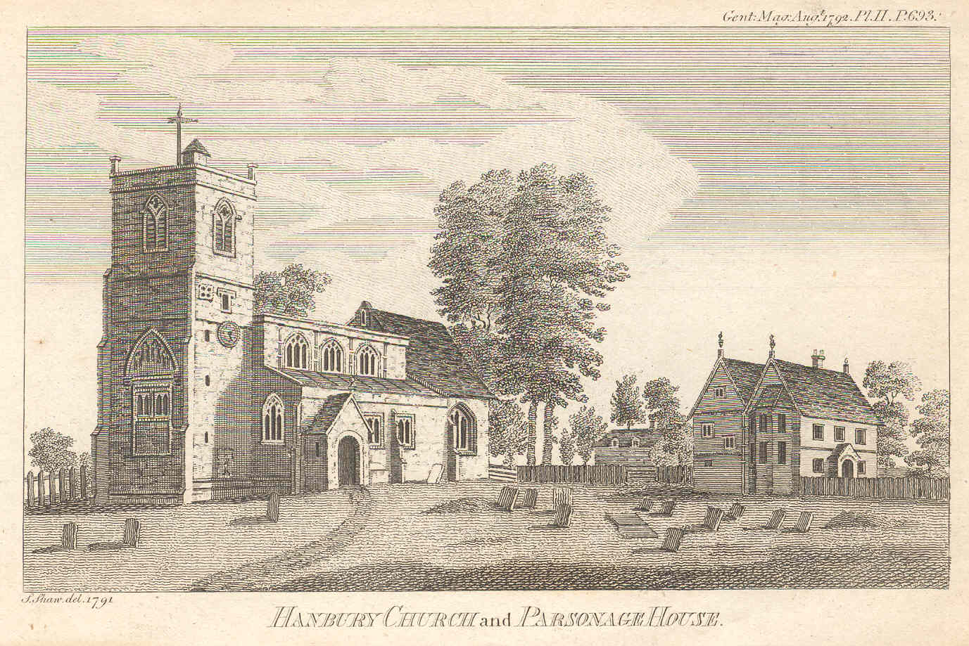
Speaking to Hanbury WI in Worcestershire I showed them various images on powerpoint, including an engraving of their church (which also doubles as St Stephen’s in The Archers!), which they all insisted wasn’t Hanbury Church. A little embarrassing! This was a bit strange because the actual engraving said it was. Was it pre Victorian alterations, with a bit of artistic licence thrown in? Then someone, when I mentioned this story to them later, said they wondered if it was a different Hanbury. I searched the internet, and yes it is Hanbury Church in Shropshire, not Worcestershire. Someone obviously came across the engraving and passed it to us, assuming it was our Hanbury and we added it!
Hanbury Church in Shropshire, not Worcestershire
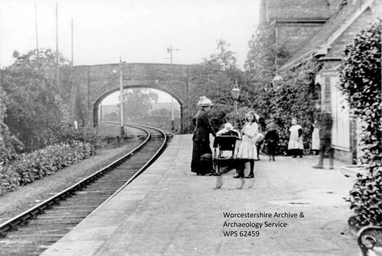
Sharing on social media opens up the possibility of people sharing their knowledge and letting us know if we’ve got anything wrong. What we thought was a photo of Broadway Railway Station which we put online is in fact Harvington Railway Station – the former was double lined and the latter single lined, so the description was obviously wrong and we’ll update.
Listed as Broadway Station, it’s actually Harvington.
As none of us are experts on our entire area we’ll all have plenty of times when we need to go with what something is labelled as.
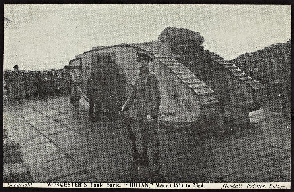
I recently came across another image wrongly titled, but one created 100 years ago and with the location printed on a published postcard. For the WWI Centenary in among the many images we used during exhibitions and projects was one of the Julian Tank in Gheluvelt Park Worcester. The Julian tank toured round the country helping to collect money from the public for the war effort. It would attract big crowds who flocked to see this new-fangled contraption, and it was ideal for encouraging donations to the Tank Fund.
Postcard which claims to be of the Julian tank in Worcester
Goodalls of Bolton produced postcards of the visits of the tank to the different towns. Except… they are not Julian and they are not of the place they say they are. I came across this when researching it to add information alongside the photo recently. The full story can be found on a website (warning – rather colourful language!). It seems Goodalls did the 100 year old version of photoshop, taking out distinctive backgrounds, and adding names of places and dates to the image to sell as postcards around the country! Apparently, the exact same image can be found with numerous town names printed on. You may have one in your collection! It shows you can’t always take what is printed on a postcard at face value. So it looks like we’d been incorrectly using it during centenary events.
So, as we have probably all found out, things aren’t always as they are described.
Social media are interactive computer-mediated technologies that facilitate the creation or sharing of information, ideas, career interests and other forms of expression via virtual communities and networks. Wikipedia
Why use it?
Most of us will be familiar with social media and use it personally so know the benefits (and problems!). Social media is also a way of publicising your service and resources. Increasingly it is where people look for latest information, and some organisations and companies now see this as their main way of communication with users rather than websites. You can get your service out among users and seen by hundreds if not thousands of users. Social media can be seen as more personal than a website, and people can respond to what you’ve posted and you can then respond to them.
It allows quick distribution of information, for instance if the library has to close early in an emergency. It also provides an easy way to share stories and images, whereas sometimes it takes a long time to get things added to corporate websites.
Journalists often search social media for stories, so media enquiries can come from reading something you’ve posted.
Local Studies collections are a fantastic resource for social media.
Main types
Blog – allows longer articles to be shared. There is often a comment facility although it is best to enable moderation on this.
Facebook – individuals join and then request friends, join groups and follow organisation pages. People (or groups) post stories, images and videos.
Twitter (now X) – sharing 240 character tweets (posts). Threads and BlueSky are alternatives which work on similar principles.
Instagram – photo (and video) sharing platform.
LinkedIn – a professional networking platform. You can create you own personal profile and engage with others and make contacts, and share stories about your service with potential partners. You can also create a profile for your library/service.
There are various others such as Tik Tok, Tumblr, Mastadon, Flickr. Each has their own character and focus, so will vary as to whether they are suitable for your purpose. Social Media trends change rapidly, and what was popular one year may wane the next, and there will be new platforms launched. Keeping track of everything is hard.
Account options
Do you have Local Studies account or just contribute to a wider library account? Check with your Comms Unit for advice as each organisation will have different policies. Some may allow numerous accounts to be set up across Libraries, with each library having their own account and a local studies account may be possible. Other may restrict, so local studies will feed into a larger account. The latter may have benefit of introducing new users to local studies and requires less content to be created.
If an account is shared by several administrators, then co-ordination is needed as to what is posted and when.
If there is a generic account for your parent organisation (e.g. Local Authority) make contact and let them know any good content they might like, as they are often looking for interesting content. Tag them in so they can reshare. Some Comms Units may not know you so it is a chance to let them know the treasures available.
Social Media Policy
Your organisation may have policies about social media so check with your Comms department. If you are contributing to another account they may also have a policy so you will need to be aware of it and fit in with their ‘style’. Most accounts have more than one Admin so the usually policy is that they all conform to the same style so people don’t know the difference.
It is best to stay clear of controversial topics and think if something could be misinterpreted. For instance if you are posting a photo of a past flood because there are current floods then be aware people may have been badly affected and phrase accordingly. If a local council scheme is controversial you may want to stay clear of posting something linked to it, or get advice.
If people comment you should try to comment, if relevant, acknowledging comments and providing more detail if available. Most libraries and heritage organisations have very few nasty/angry/controversial comments, but if you do you may want to get advice as to whether to ignore them or to engage and explain. Some organisations, though, have found an increase in negative posts on some platforms in recent years, so have decided to close some accounts.
Posts
These are some suggested advice for some of the most used platforms. You can usually get a feel for these and others through reading posts from others, and there is plenty of advice online.
Blogs – longer articles, normally a few a week maximum and not more than one a day. Takes time to write and research so post less frequent.
Facebook – No limit to text but usually 3 or 4 images maximum and a couple of paragraphs. May link to a blog. Usually only post one or two a day at most, and need to do at least one a week. Can link to a blog so people can read the longer article.
Twitter (X) – 240 characters so short and sharp, with maximum 4 images. Can tag other organisations in who may reshare. Can share link to blog. Most people see tweets in chronological order and there’s no problem in posting numerous tweets in a day, and repeating tweets to ensure as many people as possible read them. You can now link tweets as well, so if you need longer than 240 characters you can have a thread of several tweets, but it is still good to be as concise as possible.
Instagram – Photos/Videos are the main focus, so choose eye catching images.
Content
The best way to see what is good content is to look at similar organisations. You can get lots of ideas from them so have a browse. Local Studies, as you may be aware, have fantastic resources for social media as we have amazing collection. Keep an eye on the stat pages on the platform to see how well different posts are doing, which is also important to record to show your managers. Quite often you’ll be surprised at what is popular.
Service updates – new additions, changes to access, opening hours, sudden closures or still open in bad weather. Many organisations don’t update their website now with this information and just update social media.
Topical – is it a frosty/rainy/snowyday? It is the budget, Sports Relief, has a popular TV series just started or something just hit the headlines?
Hashtag Days – Just every day is a particular day, such as Biscuit Day, Handwriting day, as well as other more well known days such as Shrove Tuesday, St Patrick’s Day, World Book day or May Day.
Anniversaries – VE Day, Birth/death of a monarch, local anniversaries can all be the focus of a post
People are also interested in old photos (you may well have plenty in your collection), especially if they can reminisce.
Funny/Strange stories or enquiries
Oldest/Biggest in your collections
Subjects people are in studying (with their permission if mentioned)
Famous people in the archives
Events – advertise your workshops/talks and other events
Examples
These are a few Worcestershire examples, posted by Worcestershire Archive & Archaeology Service (posting under the Explore the Past brand) which have proven to be very popular and may inspire you.
A frosty morning inspired this photo being shared of the frozen River Severn.
When we saw this 1890 newspaper story of a hairdresser letting off a cannon in their bedroom we knew it would be popular. A host of questions spring to mind!
A sales catalogue for Bag End is always popular when it has been shared whenever there is a Tolkien anniversary or a film is released.
This Fish & Chip shop in 1968 on #NationalFishAndChipDay (7 June) caused a lot of reminiscing about going to the chippy in the past.
Copyright / Permissions
Putting images on social media is publishing so make sure you have permission for anything you post!
You may want to ensure images are lower resolution (but enough to look ok) and post your library name on along with any reference (in case people follow up and ask for it) in case people cut and paste or copy which they may do. Many people think if it’s on the web they can feely use it, so will use on their own websites and social media without permission or acknowledgement. Another option is watermarking.
Check you have people’s permission before posting photos of them online.
Evaluation
If you’re spending time on social media then you want to see how successful it is, for yourself and to show others. Again there’s plenty of advice online about measuring it. Views are good to record, but they are part of the story. Interactions, such as sharing, likes or replies, can be more useful to show how much interest it’s generated. Some statistics need interrogating further. For instance a 10 minute YouTube video may have 100 views, but when you check only 50 views were over 1 minute, and only 10 were for more than 5 minutes, giving an indication of how many people took an active interest. Another indication is whether people responded in a way you wanted them to. Did they supply information requested, follow a link to complete a survey, or attend an advertised event? It may be that a post advertising a tour of the local studies library was really popular and reshared and liked many times, but very few people actually book.
Beware!
It can be very time consuming, and responding to messages can be one of the hidden extra tasks. Have a plan for what you will do, and revisit it, to help avoid being overwhelmed. Ensure your manager is aware of how long it takes too. Being part of a larger team can help.
Remember that some elderly or disadvantaged customers do not use social media (but don’t assume, as lots of older people use it) – ensure other methods of communication are also used such as local newspapers, council flyers and posters.
There are many forms of social media and people have different preferences, and each has a different audience profile. So you may either just reach a proportion or have to use several platforms.
The social media landscape changes rapidly. Remember when young people were using Bebo, and having a MySpace account was the in thing? Then in late 2024/early 2025 quite a few organisations starting to switch from Twitter/X to BlueSky or just coming off it altogether, due to concerns over the toxic nature, and also the decline on people on that platform. You may be reading this article and thinking how out of date it sounds! So you will need to keep re-evaluating you social media policy which is of course is extra work.
Got something to add?
Do you have any comments, suggestions or updates for this page? Add a comment below or contact us. This toolkit is only as good as you make it.
Trade Directories are an early form of Yellow Pages, providing names of tradespeople, and also giving a brief summary of each town and village. They were published from the late 18th to mid 20th centuries.
Guide to resources inside and outside your collection
Trade and street directories are well-used sources of information by family and local historians. They can be used to find out where someone lived and what they did for a living. Their strong commercial focus means that they are an important source for the economic and business history of towns or regions. Their topographical information provide important clues on the built environment and geography of the past.
The first directories were published in the late 18th century. As Britain’s economy and urban areas grew in the 19th century, so did the publication of directories. They remained an important genre of reference information into the mid- 20th century. The best-known trade directory is Kelly’s, a London publisher who issued county directories from the late 1830s. They also published the Post Office Directories. Pigot and Slater, based in Manchester, were Kelly’s main national rivals until they were taken over in 1853.
There were also many regional publishers and some towns had their own directories. These provide even greater detail on local people and institutions. For instance, some will list the head of household at each address in the town.
The need for timely commercial information meant that directories were regularly updated. If you have a run of directories in your collection, then you can document changing information over many decades.
Trade Directories are usually arranged by town/village, with a section arranged by trade and one by tradesperson in alphabetical order sometimes included. There are normally useful classified indexes at the back of each volume too.
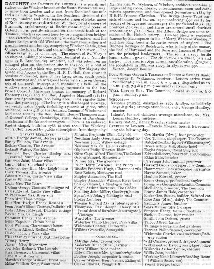
The town/village summary will list all the different administrative areas the location is part of (helpful for guiding where to look for other sources), brief history/summary of church and manor, key crops and industries, soil, population and key landowners. Public institutions are listed with the contact name. Private residents are listed, although just the wealthy ones, and then tradespeople.
(above, extract from Kelly’s Directory of Buckinghamshire, 1887)
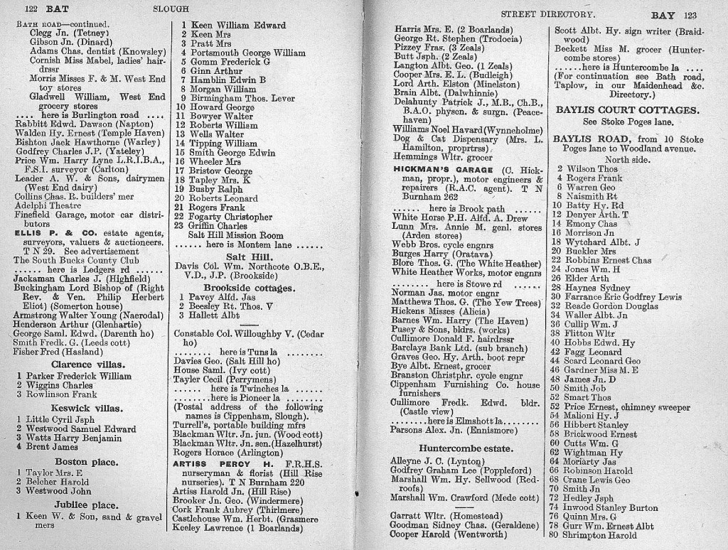
Town directories will provide the same information, but with more detail. However, as the name suggests, they only cover some towns rather than a more thorough survey provided by the County directories. Some have a street directory with the head of household listed. They will go in house order, indicating side streets, so can be helpful for pinpointing a property if you think numbering has changed. The detail of the building and street information has made directories an invaluable source for investigating how pub names have changed over time!
(Section from the Kelly’s Directory to Slough, 1932 edition)
Telephone directories, including Yellow Pages, are also available. They get bigger as more people get telephones.
Online collections
Some trade directories can be found on Ancestry and Find My Past. Ancestry also took part in a project to digitise British Phone Books from 1880-1984, however the indexing is very poor. Often it is worth searching for a common name and then scrolling through pages until you reach the appropriate page.
Back in 2002, the University of Leicester digitised over 600 English and Welsh directories in a searchable format. There is at least one directory for every English and Welsh county for the 1850s, 1890s and 1910s. The current version can be accessed: http://specialcollections.le.ac.uk/digital/collection/p16445coll4
The background pages and online bibliography are good starting points for general contextual information. The collection has been added to Ancestry and family historians may find this version easier to search. For further guidance on using the website, watch the video below:
The National Library of Scotland has digitised over 700 directories dating from 1773 to 1911. Again the background pages are a very useful starting point. The collection is available here: https://digital.nls.uk/directories/
Preservation and storage
Trade directories are books, so preservation and storage should be the same as other books. Some have maps folded in the back or other extras which may need extra care or storing separately. They can be very thick so that can cause problem with the spine.
Directories can be valuable, collectable and irreplaceable so may need extra security. Early examples from the 18th and early 19th centuries should not be on open shelves.
Physical arrangement and cataloguing
Trade Directories can be stored on the bookshelves of Local Studies collections, although as mentioned they can be valuable, so some choose to have them in locked cabinets or on demand.
Most directories can be added to library catalogues along with other books.
Innovative projects
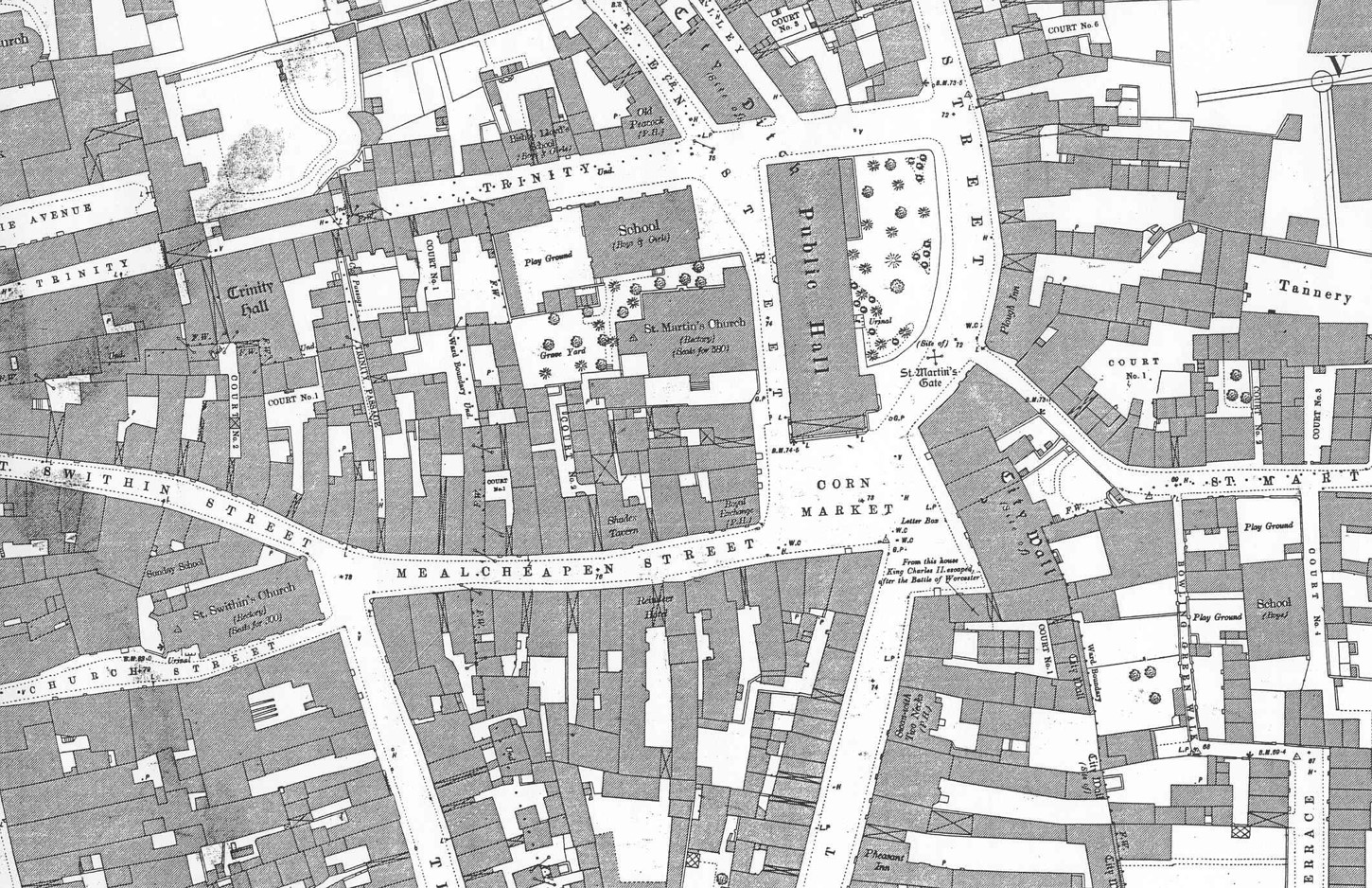
Dig Lich Street was the public engagement of an archaeological project in Worcester. The road by the cathedral was being altered to allow the creation of a new public square, and a roadabout was being removed. Excavations took place on the roundabout in advance of the new road being built over it, and the old Lich Street was uncovered. Directories were really important in enabling the story of site to be told, alongside the archaeology. The history of each property, whose foundations and cellars were uncovered, could be told. Directories provided names of occupiers, and occupations, over many years. Although around 1905 the numbering system changed which caused a bit of confusion to the project team until this was realised!
Got something to add?
Do you have any comments, suggestions or updates for this page? Add a comment below or contact us. This toolkit is only as good as you make it.
The perfect tool for showing how a geographic location changes through time and a useful tool to interpret other resources, including directories and photographs.
“All good adventures begin with a map”, Treasure Island
Guide to resources inside and outside your collection
There are a wide variety of maps, although most people think of Ordnance Survey, and that is usually what they want.
Printed – engravings of town plans, Ordnance Survey and other published maps which are sold and for which there are numerous copies. Some may be annotated by their owner before being passed on e.g by the planning department
Manuscript – one off maps surveyed and drawn by mapmakers (although a few copies may have been made). These would normally be in an archive, although copies may have been made digitally or on microfilm, or in a printed volume, so there may be access to copies in a library.
Early mapping:
Mapping as we understand it goes back to 16th century although very few maps from the period.
County maps – maps were made of the county, often more for decoration so can have limited detail, and there may be errors.
Town Plans – large towns and cities began to have town plans produced from 17th century onwards, the first often being Speed maps c1605.
Maps can also come in all sorts of other formats. Local maps are useful for enquiries and finding where places are just as much as for information for customers.
Ordnance survey:
Ordnance Survey began mapping the UK by targeting key military locations in Southern England in the Napoleonic wars. Over the early nineteenth century they slowly created county based surveys across the UK at 1” to the mile.
In the 1880s they published maps of the whole country at 6” (1:10,000) and 25” (1:2500), which were revised for a 2nd edition c1900 and 3rd edition c1914. Later editions were created, and in 1950s they resurveyed using a new grid system.
Most Libraries will also have the 1:25,000 and 1:50,000 and similar folded maps both current and historical.
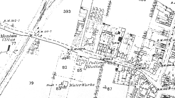
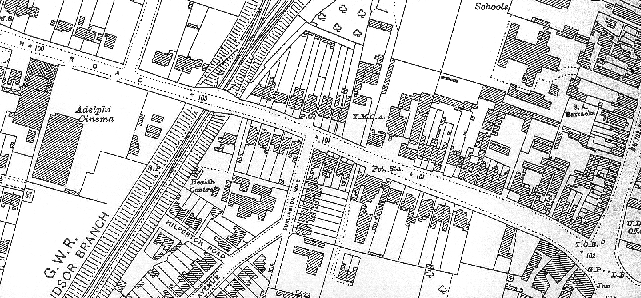
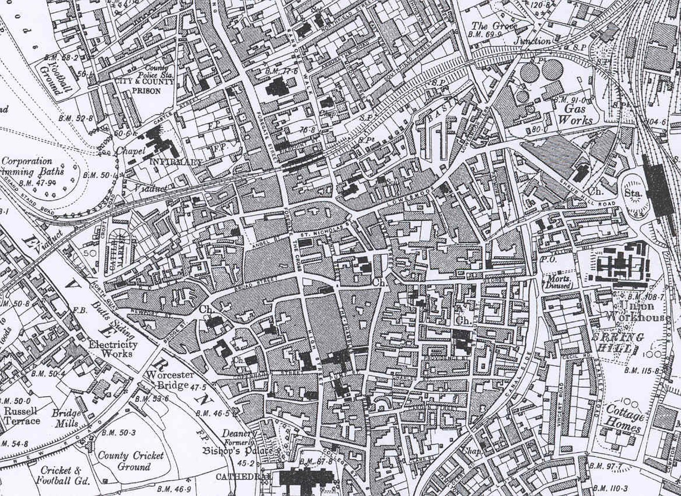
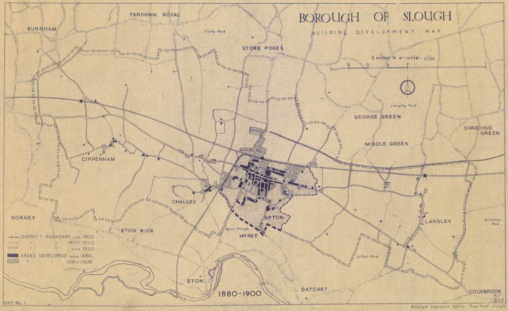
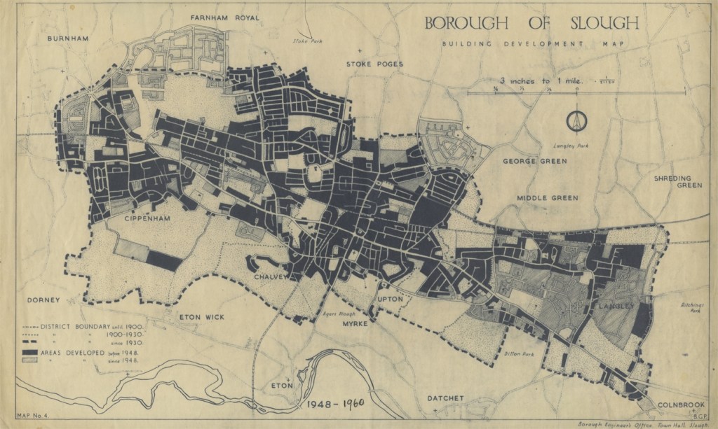
1876 OS map, central Slough1932 OS Map, central Slough 1888 25″ Ordnance Survey map of Worcester – note how much detail it includes
1901 6″ Ordnance Survey map of Worcester – to include all the buildings in the city centre some are merged together
Manuscript:
Manuscript maps are usually found in archives although some have been digitised or printed and are also available in libraries. Coverage will vary a lot as maps were expensive to create, some have not survived, whilst other may be other record offices or still in private hands. The main types are:
Estate – created by an estate owner so they can manager their land and also to show off their wealth so they are usually nicely decorated. May have tenant details. Very expensive so only shows land belonging to owner and infrequently created.
Enclosure (late 18th-mid 19th century) – map created to show new landscape after land was Enclosed.
Tithe – early 1840s, produced to go alongside apportionment when system of Tithes was changed. Apportionments have landowners, tenants, land name, use and size included, related to numbered pieces of land on the map.
Inland Revenue Valuation Office Survey of 1910 (sometimes called New Domesday), which was a national land survey, so gives similar information to the earlier tithe survey.
Local Authority development maps: Local authorities produce mapping, many of which were commissioned for reports and consultations. These can be goldmines of local information.
Street Atlas – most towns have street atlases such as A-Z or published by the local council
Goad – maps of town and city centres showing the occupants of shops. Originally for fire insurance purposes mostly used today by geography students! Part of the Experian group now so now officially called Experian-Goad maps.
Geology – maps of underlying geology published by British Geological Survey (www.bgs.ac.uk).
Other maps may cover electoral divisions, land use, streets, services, sewers etc.
Prints of current mapping can often be accessed via local authority webpages, for example https://mol.rbwm.gov.uk/mol/map/. Check with you own local authority to see what is available to you and your users.
Gazetteer of British Place Names is a free resource that allows you to search for a British place name and the gazetteer will tell you the historic and current county, OS grid reference and longitude and latitude. Very useful for researching places and cross-referencing with old maps and other sources.
Catalogue of British Town Maps is a free online catalogue of extant British town maps held in UK public archives and libraries. Essential tool for finding historic maps of a town or city.
Layers of London, with occasional coverage outside of the M25, this is an innovative project to provide digitised historic maps of London and allow organisations and individuals to data to the map (for examples photographs of buildings and streets). Some London local studies libraries have contributed HLF funded project.
Historic Environment Records (archaeological databases for counties and unitary authorities, previously called Sites and Monuments records) are GIS based and have access to historic digital OS maps and sometimes other historic maps, as well as aerial photos and LiDAR data so it is worth checking with your local HER so you can advise what they have.
Modern maps are widely available online, though Bing https://www.bing.com/maps also gives you access to smaller scale OS mapping.
Obtaining new mapping
Local authority licenses often allow them to print maps for use by the local authority. Your planning office may be able to supply you with a set inexpensively. Though online versions of mapping can be updated easily, obtaining printed sets captures your area in time and users can then compare maps over time to see how areas have developed. Due to changes in how maps were published, many archives and local studies libraries will have stopped acquiring 1:1250 and 1:2500 OS maps in the 1990s.
Microfilm copies of the first and second editions of the County Series 1:2,500 is available from the British Library.
Preservation & storage
Maps can be stored vertically in hanging cabinets, with strips attached with holes in from which they are hung, or else in flat map cabinets. Each has pros and cons. Vertical cabinets can be easier to go through.
Maps should not be folded as they will create weaknesses, although this can be hard due to space.
Some local studies libraries have maps on open access in cabinets, whilst others need staff to get them out. If open access please be aware of risk of public using big heavy map cabinets, and how to reduce maps being replaced in the wrong order.
Well used maps should be covered in conservation grade plastics. Conservation suppliers sell this plastic in rolls which can be folded and cut to size and then sealed with double-sided tape or sealed using special equipment. You can also purchase also sell large wallets made in common sizes.
Physical arrangement and cataloguing
OS maps have two different grid systems depending on whether they were produced before or after World War II.
Pre-World War II maps are numbered using a county-based two-level grid system whilst the post-war maps use the same latitude and longitude grid system OS uses today.
OS maps are not always easy for the pubic to use, and often need maps with the grids and map references marked on. They can be a struggle for staff too! Indexes can be produced which can make it easier for customers to find the right map.
Copyright
Maps are considered as artistic works, some of which have been published and some of which have not. Many maps are also based on OS mapping which makes life more complicated. See our copyright pages for further information.
Maps usually cannot be copied for planning applications, and people will need to buy and official copy. Although since most libraries don’t have 1:1250 and 1:2500 maps from the past 30 years there will be fewer people asking for them for that purpose.
For a historic orchards projects copies of maps were created which people coloured in the areas of orchards in an area, which conveyed the local importance as people could see how much land was used for this purpose at a glance. On similar principles you can use copies of maps for all sorts of base layers, annotating or colouring in items.
With Tony’s recent article I thought I’d look back at the first couple of editions after I joined the Local Studies Group back in 1996 (19 years ago???). I was at Aberystwyth University at the time, doing the postgrad librarianship course. I must admit I knew very little about Local Studies at the time, but though joining LSG and then doing the Local Studies module I realised that this was an opportunity to use my interest in history. Looking back at this edition it was interesting to see how things had changed, but many underlying questions/subjects are still here.
Vol 15 (2) Winter 1996
The main thrust of the journal was technology, with the features on digital databases, computer catalogues, internet websites and projects prominent.
The first article is on The Durham Record, a database which took advantage of the latest technology to bring together 10,000 digitised photos, historic OS maps and the Sites & Monuments Records (now Historic Environment Record). For my dissertation I looked at the use of audio-visual material in Local Studies, so it was new projects such as these that I looked at.
Although it was 20 years ago it still seems quite advanced, with touchscreen, GIS features allowing you to search via a map, and multiple ways of searching. Limits of the time meant that it had to be viewed on one of 4 standalone machines located through the county, but it was an early groundbreaking attempt at harnessing computers to allow better access to Local Studies resources. The article stresses the benefits of bringing these sources together, which we now take for granted, and all customers were interviewed said it was easy to use, an achievement considering many would be unfamiliar with computers.
Looking online today it seems that The Durham Record is still available in different formats on the web. The Durham Record itself http://www.durham.gov.uk/durhamrecord contains the images, whilst the SMR information is now on the Keys to the Past website, along with Northumberland’s HER http://www.keystothepast.info/Pages/Home.aspx. It is good to know that all that work never disappeared, which occasionally has happened.
Heritage Lottery Fund
At this stage HLF was still just a couple of years old. Nowadays most of us will have been involved, but as many wouldn’t have done in 1996 The Local Studies Librarian gave examples of relevant projects which had received funding. These included the new Surrey History Centre & The Society of Genealogists’ cataloguing project.
These were also the early days of the internet. Five key family history sites were mentioned in an article, including GENUKI & Roots Surname List, now ancestry, Find My past or even FamilySearch at this stage. It was interesting too to read that Devon were publishing a journal which would only be available digitally, a development that it very common now with groups such as the LSG looking to reduce printing and postage costs, but hadn’t realised it started so early. A further article told of a CD-ROM containing Open University dissertations, some which would be of interest to local and family historians. With developments in computerises catalogues it was also reported that some libraries who didn’t have computerised catalogues of their Local Studies collections were looking at creating these, although in some cases different collections within the same county had been catalogued in completely different ways, making the creation of a uniform catalogue a headache.
News In Brief Section
With the Norfolk Library fire only just having taken place it was reported that 17,000 items had been donated to help replace lost Local Studies items. The main problem was acquiring rare items lost, and recataloguing since the card catalogue has been burnt. A couple of my friends subsequently had their first professional posts on this cataloguing project.
Yeovil had a Local Historian in Residence scheme. The local history society helped the library by running a weekly helpdesk, precursor of volunteer help which many libraries rely on today.
It was reported that the first meeting of the Public Services Quality Group (PSQG) had met to discuss issues in archives and local studies. I’m quite familiar with it today carrying out surveys of archives at 18 month intervals, but hadn’t realised that it included Local Studies in the beginning. Anyone know why Local Studies didn’t continue being included within PSQG?
And entries were encouraged for the Alan Ball Award for local history publications, and the Dorothy McCulla Award, both of which still run today. For the latter people were asked to contact Philip Thomas, LSG Treasurer, who sadly passed away last year.
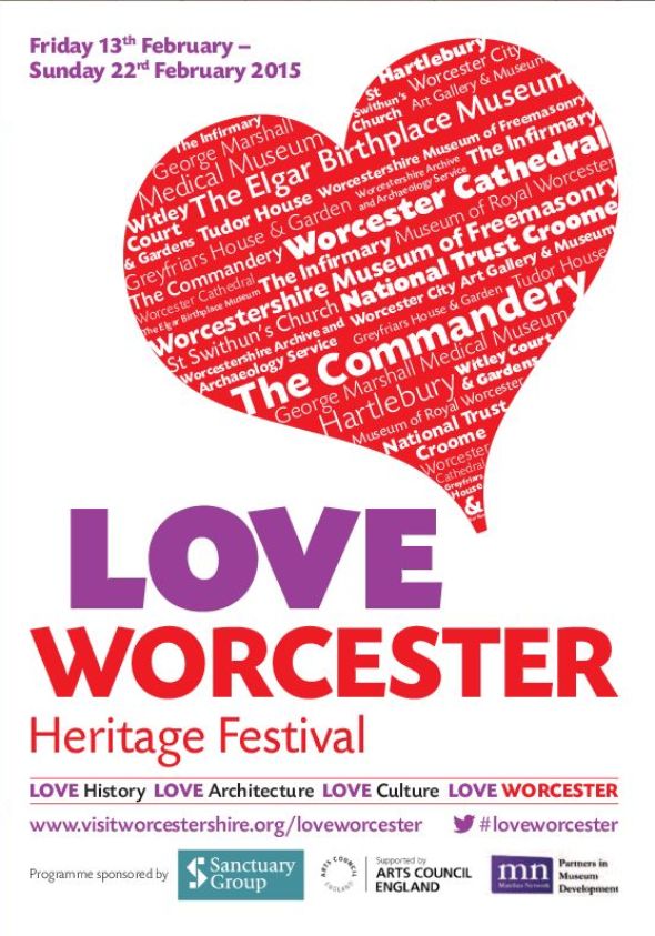
For the third year February half term in Worcester was #loveworcester. It is a festival arranged by members of the Worcester Heritage Partnership, which is a group of heritage venues in the city who meet to discuss ways to work together for mutual benefit.
It was decided that February half term was a great opportunity to badge events under a single banner, and with Valentines Day being in the period the word Love was an obvious candidate for the job.
Most events are ones we would be doing anyway, and the title or focus were skewed (some tenuously!) to fit the theme. There is no external money for this, apart from a little bit from the Museum Development Officer, and each partner contributed a small amount for producing a brochure. The local tourism body helped by providing support and publicising events on their website.
By all working together we were able to maximise publicity, ensuring that it was mentioned in the media, and on social media we all shared/retweeted each other and promoted heavily so people were well aware of the festival, which helped the individual events.
In our service we have run a few events. Our workshop on parish records was specifically run that week with the title ‘Love and death in the archives’, and in addition to the usual content I’d cover I made sure that stories of strange weddings are included.
We try to do children’s event too. Last year we asked them to draw their favourite Worcester building, whilst having photos from our collections to inspire them, and were pleased that The Hive (our new home) was a firm favourite with our young users. This year we have a day of archaeological activities, and a day of events around Dandy Row.
Dandy Row is a group of houses which has gripped the imagination of our staff since we discovered this fantastically named row of houses near the cathedral. Since then we have been looking out references to it and the residents within our collections. Using census, photos, newspapers, school records, wills, trade directories, maps, WWI records, and local history books we uncovered the story of residents who sounded as if they could have come straight from the pages of a Dickens novel, such as
Isaac Webb – Waterloo veteran & salmon fisherman of the ship Enterprise
Mrs Tandy – washwoman
John Bayliss – Royal Worcester Porcelain painter
Jermiah Pitt – labourer
Henry Martin – soldier
John Howell – publican
Other residents covered the main local industries of gloving, railways and porcelain, allowing us to tell those stories of Worcester’s past.
We borrowed object of an appropriate age to go alongside with the information we had gathered, and someone even put some of it together for a story for the Saturday storytime in the library. The children and families loved it, and we also had older people visit who could remember the street. In many ways Dandy Row is just a random collection of houses, which could be anywhere, but it was great to be able to use the sources to bring these people to life to showcase what could be discovered here. Love Worcester was then an appropriate opportunity to share what we’d discovered and share with visitors.
I was helping someone check about new local books and I was going through the library catalogue to see which were in stock and which needed ordering. I came across one title which wasn’t held so was just putting the details for ordering when I noticed that it was a Kindle only book. On further investigation I realized that it was a republication of a book first written 30 years ago, with a slightly different title, and since it was already in stock it was fine in this instance and we didn’t need this edition. It did make me wonder if anyone had come a situation where a useful local studies title was only available in e-book format and what did you do about it?
A couple of weeks ago I went to a Day Conference on ‘Schools and WWI’. As we, like many of you, are expecting an upsurge in interest from schools on this topic, I booked on.
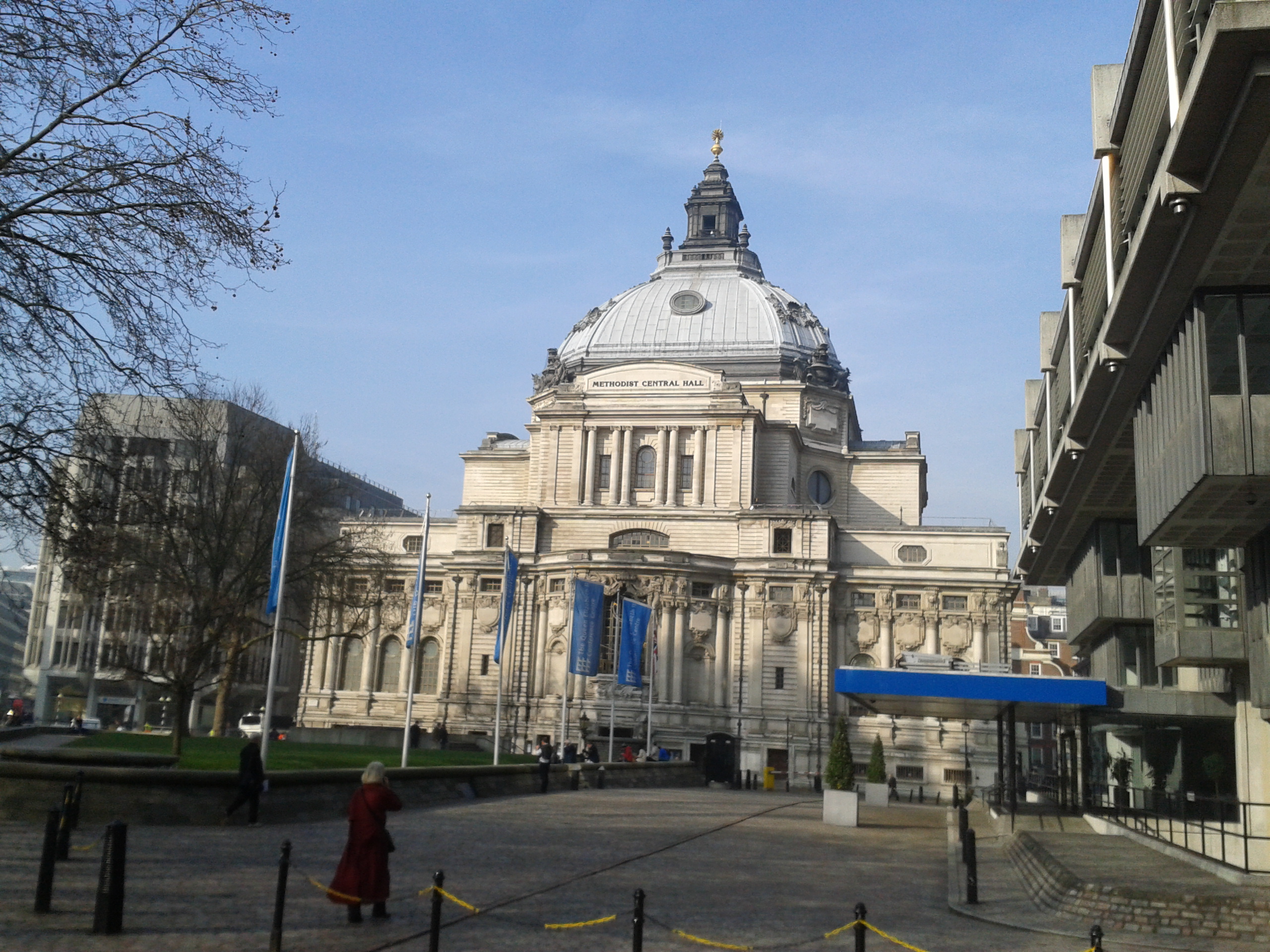
It was a very interesting day, held in Westminster Central Hall, where anti-war meetings took place in summer 1914, and where the United Nations first met. It was rather different from most day schools and conferences I’ve been to. Partly on scale, over 400 people there, and speakers, with Jeremy Paxman, Ian Hislop, Michael Morpurgo and Huw Strachan among the speakers!
It was noticeable how most people start with their personal connections, just as speakers did at the LSG Day School last year, highlighting that it is the personal connections which draw us in. Having said that, Huw Strachan said how when he spoke to a class recently none of them knew of their own family connections to WWI. As they are going on a trip to the battlefields it is likely that they will be discovering these connections and will be educating their parents, and we’ll have the opportunity to help this.
I did get a bit concerned when Strachan said he was worried at all the focus on the local stories, as that is what most of us do! I was fearing our ideas crumbling. Fortunately he went on to say that this is only when it is left only at that level, and that local stories/people can be used to illuminate the mega narrative. Whilst people struggle with big topics such as Gallipoli, The Somme, the scale of casualties, they can be taught starting with the local aspect and then going onto the big story, so local studies is still very relevant to this.
Another theme was challenging the stereotypes. Ian Hislop spoke about the Wipers Times, showing clips from the TV drama, which I felt a little embarrassed at not having seen yet. He was saying that whilst the war poets are covered we should not forget the satiricists, who present another view, which is just as valid. He said he was keen that we shouldn’t condescend the past we should treat people as people and that they knew what they were doing. Other people said that preconceptions need to challenged, for instance only 56% of casualties were in France/Flanders with the rest elsewhere in the world; a large proportion of casualties died outside of the major setpiece battles; and that ‘only’ 1 in 8 British servicemen were killed which is less than most think, although many who came back had physical or mental wounds which we should consider. This corresponds with projects I know about in Worcestershire, looking at the Home Front (often ignored in WWI History), and the Worcestershire Regiment in Gallipoli, Iraq and Egypt.
One disappointment was that there were limited references to local sources. I realise I’m biased, and we are just one source, but it would have been great for teachers to hear about the information we have which can help. Michael Morpurgo touched on the power of letters and other documents, real objects which prove that something was not just a story. A speaker in the afternoon, Barry Blades, gave a short 10 minute talk on how schools could tackle a history of their school in the war. Interestingly he left the war memorial, often used as a starting point, to the end, as chronologically it comes after the war ends. He has a website www.ww1schools.com which goes through in more details (although a little concerned that he talks about school logbooks without mentioning that many are closed for 100 years which could be a problem). Another speaker, talking about visiting battlefields, discussed local enquiries schools could do before and after their trips, but other references were sadly few. The BBC, Imperial War Museum and Commonwealth War Graves Commission had opportunity to explain about their new online resources, but it was a shame little reference was made to local museums, archives and local studies libraries. There was also no opportunity to give ideas for lesson plans and activities, which I was a little surprised about. However it did prompt me to discus with colleagues about creating a brief guide for teachers when I got back to Worcester, and reminded me that there is probably a need with teachers for this information.
It was an interesting day with fascinating speakers, even if I’d have changed a few things. It reminded me how big this topic is, how important it is for it to be commemorated, and that there is a vast amount for people, school children included, to discover over the coming years with the TV programmes, exhibitions, books and events which are planned. And this is something local studies can contribute to.